
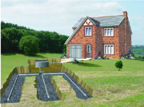
The Importance of a Proper Septic Design in CT
Designing a proper septic tank is a vital part of constructing a property that cannot access the local sewer system. In fact, the final design of a property cannot be completed until the ideal location of the septic tank has been decided upon. Doing so will help to ensure big savings on the construction and design of the septic tank.
Hiring a Civil Engineer
It is critical to hire a professional septic tank designer to survey and analyze your land before you begin constructing your new property. The professional will examine the lay of your land and perform various soil tests to establish the best area to place the septic system. During this assay process, they will also put into consideration the place you wish to position your home. Click here for a free quote for surveying and septic design from Godfrey-Hoffman & Hodge.
Steps to take following consultations with a professional septic tank designer
In certain cases, the septic tank designer will ask you to change the place where you wish to construct your home in order to ensure proper working of the septic system. This will help you to save on the investment since most septic tanks are designed to follow a downstream flow. This therefore means that gravity fed septic designs cost less than those that require pumping to work effectively. In addition, a gravity fed design has lower maintenance costs and has fewer breakable moving parts.
If a regular septic tank design will not work well for you, you can request the design specialist to provide you with alternative options at your disposal. Ensure that you clearly understand the pros and cons of each option before making a decision on which one to go for.
Septic tank zoning and codes requirements
Your septic tank design must meet the relevant zoning and codes requirements. A reputable contractor should be able to meet all these requirements. Your local civil engineering company that oversees the designing of septic tanks should approve the plan before proceeding with its installation.
Key Takeaways
- Hire a professional septic tank designer to survey your land before undertaking any property construction
- Ideally choose a gravity fed septic design since it cost less than one that requires pumping to work effectively
- Understand the pros and cons of alternative septic tank designs before installing any of it
- Your septic tank design should meet all relevant zoning and code requirements before installation
The Importance of a Proper Septic Design in CT

Designing a proper septic tank is a vital part of constructing a property that cannot access the local sewer system. In fact, the final design of a property cannot be completed until the ideal location of the septic tank has been decided upon. Doing so will help to ensure big savings on the construction and design of the septic tank.
Continue reading “The Importance of a Proper Septic Design in CT”
Easements aren’t as Easy as they Look!
What is an Easement?
 An easement is the right one party has to use the property of someone else. This kind of arrangement occurs in many situations. For example, if one person needs to cut through another lawn to get to their favorite fishing pond, then this is called an easement. However, there are many other scenarios in which this occurs when the law is concerned.
These include the previously mentioned scenario, support, and waterway easements. In addition, there are also the types of easements that block one from doing something on one’s property; this is called a negative easement. Easements are used for both individual reasons, and for business purposes.

Holiday Help from Godfrey Hoffman Hodge, LLC
This Christmas Eve, Steve Strinie, a 30 year Hodge employee will be lending a hand at the WTIC/Salvation Army Holiday Store in Avon Ct. collecting packages and sorting items for the annual donation drive. This is Steve’s third year at the event!
Ray Dunaway from WTIC being familiar with Hodge Surveying, talked about the old days when his former next door neighbor and Hodge owner Weston Barnes (circa 1937-1980) would go over to Ray’s house on Christmas morning and broadcast his morning show live from there!
Godfrey-Hoffman & Hodge would like to thank Steve for being a contributor to this worthy cause and carrying on a great tradition.
Common Scenarios for a Septic Repair Job
Few things can be more distressing for a homeowner than a problem with the septic system. Even householders who are vigilant about reducing the water load and ensuring that the tank is pumped regularly can find themselves facing an unpleasant situation if something goes wrong. While there are many things that can go wrong with a septic system, they can be roughly grouped into a few common scenarios.
Blockages
Clogs and blockages are a routine problem for septic tank systems. Blockages at the inlet can prevent waste from entering the tank, causing it to back up; blockages at the outlet prevent liquid from entering the leach field and will eventually cause the tank to overflow. Sometimes these arise because the wrong items are being put into the system: cooking oil and grease can cause major problems, as can feminine hygiene products and the wrong kind of toilet paper. Algal blooms and biofilms can also form barriers that stop the tank draining properly. Blockages may be often resolved by snaking the system but sometimes the tank needs to be opened up and the clog removed.
Minor Repair Scenarios
Septic systems are made up of several different elements. Over time, one or more of these may begin to fail an will need to be replaced. These include the pipes and fittings; septic tank risers (connections between the septic tank and the surface, facilitating pumping); baffles, which prevent solid waste from escaping once it has entered the tank; and filters, which can become clogged over time.
Major Repair Scenarios
While septic tanks are minutely inspected before being installed, cracks and weak spots can form over time. A septic system only has a finite lifespan, typically around 20-25 years. Systems can fail faster if they are not properly maintained or if the homeowner uses the system incorrectly (for example, by pouring caustic chemicals such as paint thinner down the drain). The tank will need to be dug up and exposed for repairs to take place; in the worst case, it may need to be replaced all together.
Prevention
Using a professional civil engineering company to assess the situation on your property can be extremely valuable in the long run. Hiring an experienced firm to come out and evaluate a septic system is extremely important before purchasing a new property, whether it’s residential or commercial. If your hiring an engineering company for new construction, they will take your septic design from a plan to a design and gather all legal permits along the way. For more information about a septic repair on your property, click here.
Key Takeaways:
– Conduct regular maintenance on your tank
– Routinely pumping the system
– Use the system correctly to reduce the number of repairs.
– Conduct minor repairs involve fixing or replacing components such as filters.
– Major repairs will require the replacement of the septic tank.
Common Scenarios for a Septic Repair Job

Few things can be more distressing for a homeowner than a problem with the septic system. Even householders who are vigilant about reducing the water load and ensuring that the tank is pumped regularly can find themselves facing an unpleasant situation if something goes wrong. While there are many things that can go wrong with a septic system, they can be roughly grouped into a few common scenarios.
What are the Benefits of GPS Survey tools?
About GPS
Global Positioning System (GPS) technology is a space-based radio-navigation system that provides users worldwide with valuable information including three-dimensional position, navigation, velocity and time data. It comprises of 24 satellites, which are in orbit some 12,000 miles above the earth’s surface. GPS operates on the principle of triangulation. The satellites broadcast their position on a continuous basis, and by combining the measurements from different satellites.

Continue reading “What are the Benefits of GPS Survey tools?”
Everybody wants one..but can you build a pool on your property?
Can You Build a Pool on Your Property?

A pool is surely an eye-catcher and it can be a major entertainment and recreational spot on your property. It offers privacy, comfort, and convenience. If you want a pool on your property, everything boils down to basically having enough space for the pool and how much you are willing to spend for it. You must be warned, though, that if you are planning to resell your property in the future, having a pool does not necessarily increase its selling price since some buyers might be put off by safety and maintenance concerns.
Continue reading “Everybody wants one..but can you build a pool on your property?”
The Role of the DEEP and Your Property

When looking to develop your property, whether it be residential or commercial, the DEEP (Department of Energy and Environmental Protection) plays an important role. The DEEP helps to insure that your property is not going to cause any damage to the local environment when starting new construction, or that if you are looking to change the boundary lines of your property, that it will not encroach on protected lands. This service is very important for both the property owners, insuring that they are not breaking any laws, and the environment alike.