GHH Celebrates 100 Years of Quality & Accuracy!

Building on Trust, Delivering Results:
Godfrey Hoffman Hodge Celebrates 100 Years!

We’re pleased to share the news of this milestone and look forward to continuing to do what we’ve been doing for a century: providing our clients with fast, accurate and quality services. Here’s a brief history of how we got here:

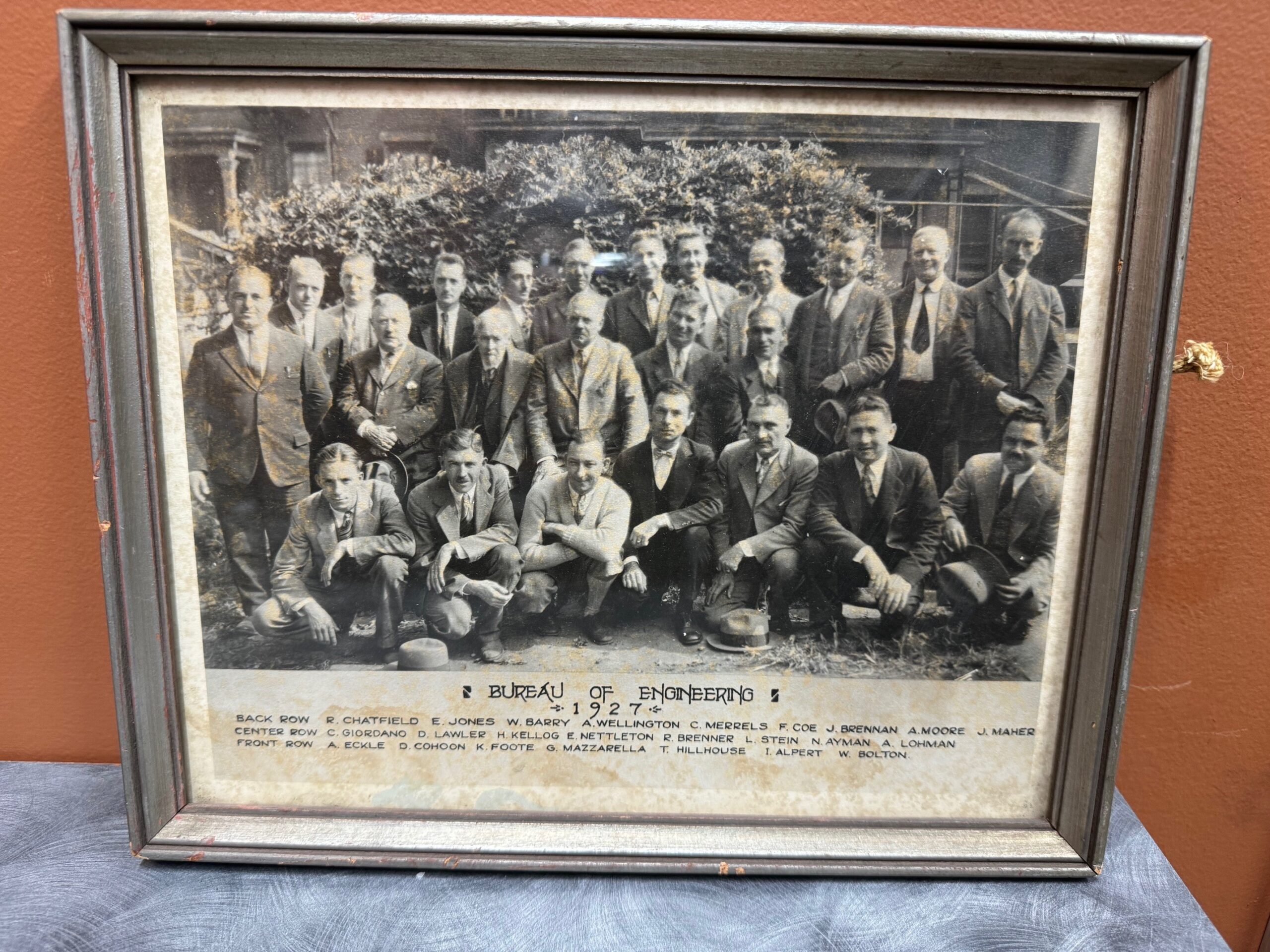
1924: The story begins when two young engineers, recent Yale graduate Lewis Stein and Constantine “Gus” Giordano meet while working for the City of New Haven Engineering Department. Together, they set out on their own and forge a partnership in New Haven, laying the foundation for a legacy in land surveying.

Bernard Godfrey enters the scene. While still in high school, he learns the ropes under Stein & Giordano’s guidance, igniting a lifelong passion for the field. His journey takes him through forestry, entrepreneurship, and back to surveying, eventually marrying Stein’s niece and taking over the firm in 1960.

Enter the next generation: Adam Hoffman, Godfrey’s nephew, joins the firm in 1977, inheriting the family’s dedication to precision and service. He expands his expertise with a forestry degree and land surveying minor, rising through the ranks before becoming a partner in 1988. The firm rebrands as Godfrey-Hoffman Associates.

The 2000s usher in expansion. Godfrey retires in 2000, and Hoffman restructures, solidifying the company’s future as a Limited Liability Company. The firm ventures into engineering with the addition of Victor Benni in 2001, further diversifying its offerings.

2010 marks a pivotal moment. Hoffman acquires Hodge Surveying, a Farmington Valley mainstay since 1925. This strategic move broadens the company’s reach and expertise.

Finally, in 2019, the two entities merge to become Godfrey Hoffman Hodge, LLC. This marks a culmination of nearly a century of dedication, bringing together 100 years of combined experience in land surveying and engineering.

Today, Godfrey Hoffman Hodge stands as a full-service powerhouse. We tackle projects across Connecticut, serving public, private, commercial, residential, and industrial clients. Our commitment to quality, accuracy, and cutting-edge technology ensures every project receives the attention it deserves.

Tools From The Field

Accuracy Matters.

We incorporate the latest tools and technology in pursuit of capturing robust surveying data in the most efficient manner – all for the benefit or our clients.

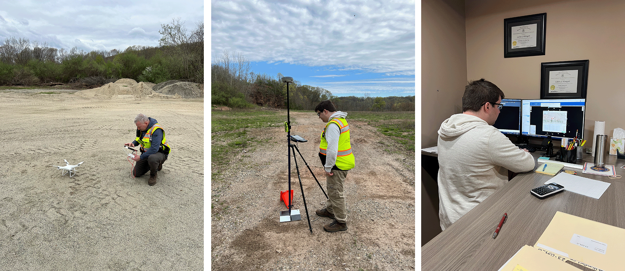
Here, Calvin Weingart enters flight data and commences a drone flight. Utilizing this tool gives the ability to augment data collection on sites. In this case we are doing so in Wallingford and East Haven, CT.

Once the flight is complete, team member Ben Weingart monitors the collection of GPS data on a ground control point. This data allows the team to precisely relate ground positions to target locations captured by the drone. Once the field work is done, Ben works in the office to perform the corrections and commence processing.

Accuracy Matters – we have the tools and know-how to help with all your surveying needs.

Laser Scanning of Existing Buildings for BIM and Deep Energy Retrofits

Deep Energy Retrofits of Existing Structures

High-performance energy systems and building envelopes are not reserved for new construction only. Existing structures are being equipped with energy efficient HVAC systems and retrofit with engineered thermal insulation and vapor envelopes, passive solar shading devices, active solar panels, and water conservation strategies – all in an effort to reduce the energy consumption in existing buildings.

Energy-efficient systems and renewable energy sources are the two common paths used to improve a statistical fact concerning built environments:

“On average, 30% of the energy used in commercial buildings is wasted, according to the U.S. Environmental Protection Agency….one of the top opportunities to improving the energy efficiency is retrofitting of existing buildings.”

Deep energy retrofits – as opposed to conventional energy renovations which focus on simple upgrades of isolated systems, such as lighting or HVAC systems – will approach the whole building and its overall poor performance ratings. Many building systems are addressed at once for a much greater savings in energy consumption, increased occupant comfort, and reduction in green house emissions.

Laser scanning of existing structures is used to accurately capture hidden building elements and attain dimensional data as the first step to creating a building information model (BIM). With a 3D BIM model of the retrofit project’s interior, exterior and surrounding site, energy modeling tools are then used to simulate the thermal properties of the building envelope, visualize interior heat loss and gains, emulate the position and the effect of the sun for solar shading strategies, and as a tool to improve overall building performance.

Laser scanning is a land surveying software solution that facilitates the engineering and construction phases of architects, engineers, and construction. This as-built tool replaces traditional building and land surveying methods by using hand-held laser measuring devices, photogrammetry, or unmanned aerial vehicles (UAVs), to capture and analyze building data in real time. Elevations, sections, floor plans, and complete 3D models are converted to 2D drawings, 3D models, or BIM-compatible formats.

This virtual capture of the environment becomes an important part of the planning process for deep energy retrofits, land development, urban landscape planning, and in the new construction process. Using Bluetooth technology, PC tablets, and reflectorless instrumentation – highly detailed and very precise building or land surveys are quickly accomplished – all in the digital (or virtual) realm. The end-use can beapplied to solve a number of structural and architectural documentation needs, including:

  • General Arrangement Plans
  • Street Scenes
  • Scaled Floor Plans
  • Internal Elevations
  • Roof Plans
  • Facade Measurements
  • As-Built Checking
  • Field Clash Detection

Laser Scanning and Point Cloud Data

Point cloud technology utilizes high-definition CT laser technology to scan multiple perspectives of the physical environment. The resulting image consists of millions of data points capturing the targeted image in a 3D coordinate system, or point cloud. The raw point cloud data is automatically converted to real-world structural elements and terrain features to generate accurate geometric data of building interiors and exteriors, topographies and urban landscapes, and even manufactured items such as pipes, and machinery.

Industry consensus supports the efficiency of using scanning to produce point cloud data to augment 3D modeling (and especially BIM applications)The once fragmented space that existed between retrofitting of existing structures and utilizing advanced modeling technologies are removed with 3D laser scanning services. This virtual, digitization of environments allows real-time, concurrent workflow to share information between field and engineering office. With laser scanning-to-BIM, all of a project’s stakeholders can access an integrated project database for engineering analysis and building performance studies – connecting existing infrastructures with analytical modeling and visualization technology for installation of deep energy retrofits.

Contact us to discuss how time, money, and effort can be saved in retrofit projects of built environments.

Land Surveying in Road Design

Roadway Design


Land surveying
 is the science of determining the positions of points on the landscape and the distances between them. Land surveying plays a vital part in the beginning of a construction project, especially the construction of new roadways. Land Surveyors are qualified professionals who use sophisticated instruments to make precise measurements to determine the boundaries of your property or a construction site. 

One of the most important services that a Land Surveyor in CT provides is determining important points and the boundary of a construction site. The elevation of different points of the construction site and its distance from locations, such as water sources or areas where construction is not permitted can affect the boundaries of your project. Knowing that kind of information is vital for both architects and engineers; without it, they cannot formulate the appropriate designs or plans. The input of land surveyors can help avoid costly and dangerous errors in road building and roadway design.
 

The Location of Roadways

Continue reading “Land Surveying in Road Design”

THE CHURCH OF ST. PATRICK – MAIN ST. FARMINGTON

Hodge LLC. has been working at St. Patrick’s over the last few years completing boundary, topographic surveys as well as locating the buildings, parking lot, trees and all physical features on the site. The main building was built in 1921 with several newer additions. The information gathered by us will be used by the engineers to design much needed parking. Also on the property is an old house that is to be rehabbed along with a new driveway which will serve as the new rectory.

Students to Learn from New Surveying Equipment

Land surveying should be considered an art form of sorts, instead of just a means of determining the level of land in certain areas. At a base level, surveying is a technique wherein terrestrial position of points and the angles and distance between them help establish land maps, the perimeter of areas and other ownership and/or governmental purposes. Many times, this blog has referenced the amount of skills that a land surveyor must have to complete this task, from a knowledge of mathematics to physics to law and everything in between.

According to Opti-cal, some engineering students in Ireland are going to be able to use some new, high tech surveying equipment to make their measurements and estimations more accurate:

“The Galway-Mayo Institute of Technology (GMIT) has taken delivery of a Leica Viva TS15 Robotic Total Station, which will allow students to learn how to undertake high-end surveys on the exact equipment that is used by professionals the world over. The students will be able to use the total station to take laser distance measurements of up to 3.5 kilometres. It is the latest addition to the institute’s advanced surveying equipment, having had a GPS station installed on the Dublin Road campus last year.”

This type of technology will be able to integrate with computer aided drawing software, the kind which locally based CT engineering firms use to model buildings and the area surrounding them. By syncing this type of software up with the new tools, surveying students can complete some architectural navigation of a buildings, land masses and other necessary areas. This type of technology helps immensely with efficiency as well – because the 3D models that are made are so accurate, return trips to the project site are rarely needed.

Massive Shortfall of Engineers in India

The job market is tough out there across North America, especially in the United States.  Although some types of jobs are opening up – medical, engineering and food service fields specifically – it has still been difficult for many to find places to work in this hard economic state.  However, if an engineer is finding no open positions in his/her area, they may want to look towards Asia.

Recently, there has been a construction boom out in India that is seeking civil engineers and designers for help in building high rise apartment buildings and the like.  The shortage has developed out of a lack of Indian graduates moving into those fields – instead graduates are working in the information technology field, which is always seeking in India.  According to the Economic Times the salary for someone in civil engineering versus someone in information technology is roughly half, causing a serious shortage:

“Infrastructure problems ranging from dirt roads to power cuts are a major obstacle to India’s future growth, and the government plans to spend one trillion dollars on upgrades between 2012 and 2017. India has jealously watched China’s remarkable economic development over the last 20 years, which has been made possible by huge and successful public construction projects. Experts however warn that India faces a massive shortfall of qualified civil engineers. Delhi’s new metro system is one shining example of the type of project that would be welcomed across India. But when a new stretch of track opened before the Commonwealth Games, the chief of the project E. Sreedharan complained bitterly about a ‘severe shortage of architectural and civil engineers.’”

This story highlights the importance of all kinds of engineers across the world.  Not having enough civil engineers may stall India’s movement towards growth in years to come and that would be a shame.

3D Laser Scanning Saves Time

Laser technology in the fields of engineering and land surveying is sweeping across the country. By using lasers to map coordinates, shapes and elements of an area that will be constructed upon, engineers can quickly, accurately and effectively capture the full breadth of an area. Laser scanners produce point clouds that can be turned into 3D or even 2D models of buildings and landscapes that can be used for planning and other data collection. Laser technology is definitely the future of engineering and surveying and schools are jumping on the bandwagon with high tech engineering firms.

For instance, this technology is being taught at the Nova Scotia Community College in Dartmouth, Nova Scotia, Canada, according to The Chronicle Herald. Students at the school are learning how to use the laser scanning tools to create models of structures automatically from hard resin, instead of paper. The article explains the process:

“Brandon Smith, a mechanical engineering instructor, waves a laser wand around an angular piece of metal in a workshop at the Nova Scotia Community College in Dartmouth. A few metres away, the information from the laser sensor appears on a computer screen, slowly building into a three-dimensional replica of the object, which was once part of an airplane. That computer image will be fed into a large “printer” on the other side of the room and in a matter of hours, an exact three-dimensional replica of the part — made of a hard resin material, not paper — will be produced for the aviation company IMP.”

This type of process would have taken weeks without the technology now available to students studying engineering in schools all over the world. The article goes on to say that the skills associated with using these types of tools will help students get acclimated with real-world “customers, deadlines and engineering challenges.”

Wooden Whaling Ship Back in the Water

In this blog, we have discussed the usage of laser technology to create 3-D models of buildings to help aid engineers with recommendations for land that is complex and time consuming to survey with standard engineering tools. Technology is one of the major backbones of engineering and 3-D imagery is just one of the newest techniques for making the science of engineering more precise and accurate.

Using lasers as the “eyes of an engineer” can be a very effective way of determining how a structure needs to be fixed in order to achieve maximum stability and long lasting structural integrity. A 3-D scan provides engineers with a model that looks very similar to the computer generated imagery used in the classic movie “Tron.” Using this technology paired with the engineering skills gained from the study of math and science, engineers can interpret a model and make recommendations to clients. This process also saves a massive amount of time for engineers, who would normally have to manually make measurements on difficult pieces of land.

This process isn’t just used for scanning areas of land and current building structures, but also used for restoring old ships, according to this blog entry from Gizmodo. The entry speaks about the restoration of the world’s last great whaling ship, the Charles W. Morgan. The wooden ship was scanned with lasers and X-ray technology to determine where its weak spots are, so that a $10 million restoration could begin.

According to the piece, the boat should be restored by 2012, but that whaling will not be possible. At this point, the boat will be preserved for history’s sake. Without 3-D scanning technology, the last whaling boat in the world would be gone forever.