How Land Surveyors Set The Stage For A New Building

This Is How We Do It…

This sequential photo montage highlights all the phases involved in preparing a site for the construction of a new building.

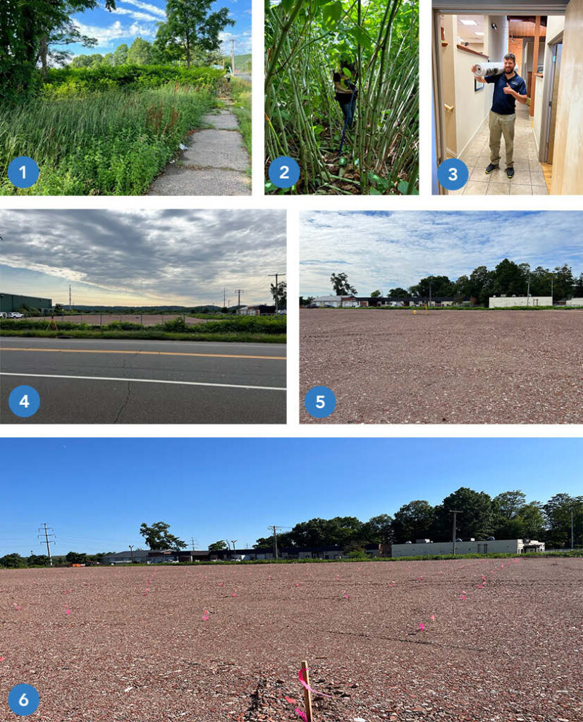
  1.  The undeveloped, overgrown site in Hamden, CT at commencement of survey work.
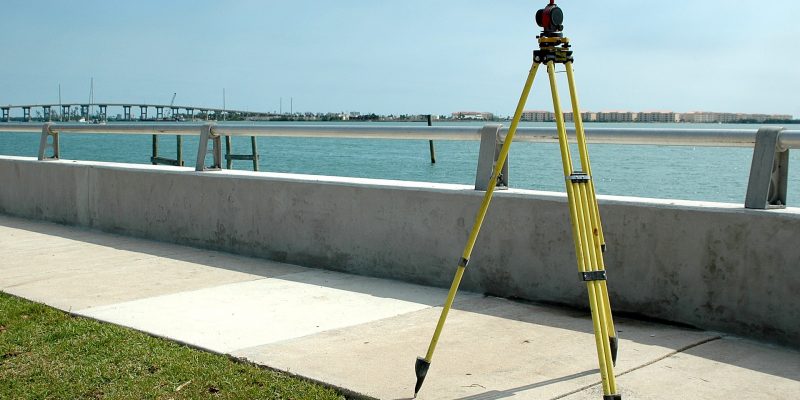
  2.  Site conditions during field work with survey gear.  As we often do, our crew contends with towering, tangling vegetation.
  3.  A year later, after site design and the permitting process, the finished plan set is delivered to the town permitting agency.
  4.  The site is cleared and prepared for construction.
  5.  The crew and survey instrument are in position to locate and mark 384 points for Helical Pile installation.  (These piles, or piers, are used to stabilize soil to support the building foundation).
  6.  The pier stakeout is complete and the site is ready for the pile driving crew to commence work. Each location is identified by the  pink whisker flag and orange numerical identifier.

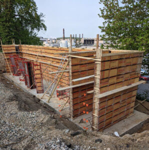
Once the piers are installed the foundation will be marked out for construction.

Stay tuned for updates as we follow this project to completion!

Building a Solid Foundation, One Form at a Time

Foundation Rising.

Building a solid foundation is a critical part of any construction project, and it requires careful planning and execution every step of the way. At GHH, we understand the importance of getting every detail right, from the initial site survey to the final construction stakeout. That’s why we’re proud to be part of a project that is now seeing the foundation rising, one form at a time. 

This project started with a site survey, which allowed us to gather important information about the site’s topography, existing structures, and potential obstacles. Based on the results of the survey, we were able to develop a site plan that met the client’s needs while also complying with all applicable regulations and zoning requirements. We then worked with the client to obtain the necessary permits, ensuring that the project could move forward. 

Now, with the foundation rising, we’re seeing the culmination of all that hard work. The concrete forms are being carefully placed and secured, ensuring that the foundation wall will be strong and stable for years to come. As the foundation takes shape, we’re reminded of the importance of attention to detail and precision in every aspect of the construction process. 

At GHH, we take pride in our ability to deliver high-quality surveying and civil engineering services that help our clients achieve their goals. Whether we’re surveying a site, developing a site plan, or providing construction stakeout services, we bring the same level of professionalism and expertise to every project. As we continue to work on this project and watch the foundation rise, we’re excited to see the results of our hard work and dedication taking shape.

Tales From The Front Desk

How GHH Helps When You Call…

A short interview with GHH Office Manager Maria Latella lets you know how we can help you with your needs and goals. A GHH inquiry intake story:

What does a typical request look like?

Depends on the caller’s specific survey or engineering needs but most of the calls are for services related to residential property, commercial property, elevation certificates, additions, subdivisions or construction layout.

What kind of information do you need or are listening for during these conversations?

It starts with contact information, who a proposal should be sent to (it does vary depending on the situation), who will be responsible for financials, and finally, what is the purpose of the survey or engineering services.

What happens after gathering the basic information?   Does the conversation end or continue?

It might end with a brief description of what the client can expect for next steps or it might continue depending on input from the client.  For example, if a client is unsure of what specific type of survey is needed we can ask some questions about what they are trying to accomplish.  If they want to see where their boundaries are marked on the ground that is one type of survey.  If they are planning on improvements to the site, that is another kind of survey.  In addition to helping determine the type of survey needed, it’s a good chance to describe the value of each.

Is it difficult to get to that point in the conversation?  Do you listen for key words or specific scenarios the potential client is referring to?

We listen for key words such as “flood insurance” or “I live on the shore” which most likely relates to completing a flood certificate.  Or, phrases such as “ I want to do an addition” and“ We have land we want to subdivide” can help drive what type of service is needed and how we can help.   Most clients are not aware of the various types of surveys so we try to lead the conversation to narrow down the list in order to provide the most appropriate proposal we can from the start.

How do you leave off with a client?

I will always explain next steps, specify who will accomplish them (e.g. , a Licensed Land Surveyor or Professional Engineer) and when to expect communication.

What is your overall goal when speaking with a potential client?

The goal is to convey a sense of confidence, that we are patient, that we care about their request and care about their end goal.

What is one thing you want clients to know when they call Godfrey Hoffman Hodge LLC?

There are lots of way we can help with your needs/goals.  The more we communicate, the better, and faster we can help

GHH Acquires Woman Owned Winterbourne Land Services

Winterbourne Land Services: A pioneering surveying firm for women land surveyors

GHH Acquired Winterbourne Land Services, a cutting edge woman owned firm, on November 15th, 2021

The Woman Behind Winterbourne Land Services 

Winterbourne Land Services is a Connecticut historic Land Surveying and Civil Engineering company, established in 1993 by Rosalind C. Page. The firm was one of the first woman owned land surveying companies in the state. Rosalind was one of the few professionally licensed female land surveyors at the time. The Winterbourne team has worked on an abundance of private, commercial, and municipal projects of all shapes and sizes. The firm has performed work within New Haven, Middlesex, and Hartford counties.

Avon Village Center Opening 🎉

Avon Village Center welcomes you! GHH’s newest development with the Carpionato Group

GHH helped develop the newest retail development in Avon, the Avon Village Center with its partner, Carpionato Group, furthering its stake in the commercial development industry, on September 1st, 2021

Developing the Center 

Avon Village Center Ribbon Cutting Ceremony
Ribbon Cutting Ceremony

Godfrey Hoffman Hodge and the Carpionato Group have been working hard on creating the newest commercial development in Avon, CT, Avon Village Center. This modern commercial and residential hybrid development is sure to stay with opportunities abound for locals.

The first retailer to open in the center was the Whole Foods Market, guaranteed to draw large crowds. GHH is proud to announce that we were a part of the ribbon cutting ceremony for the Whole Foods,  formally announcing the opening of the center.

To learn more about the complex’s beginning stages, check out these articles: https://patch.com/connecticut/avon/avon-village-center-phase-1-complete

https://www.avonct.gov/planning-community-development/pages/avon-village-center-project

https://www.carpionatogroup.com/property/486/avon-village-center-avon

Continue reading “Avon Village Center Opening 🎉”

Clarence Blair Associates circa early 1900s

GHH Acquires Clarence Blair Associates 🎊

Clarence Blair Associates, Inc. (CBA) Acquired by Godfrey Hoffman Hodge, LLC. (GHH)

Learn about the historic acquisition of Clarence Blair Associates, one of Connecticut’s oldest surveying & engineering companies.

Godfrey Hoffman Hodge, LLC. (GHH) Is pleased to announce our acquisition of Clarence Blair Associates, Inc. (CBA), as of March 2021. The firm’s extensive historical records will greatly bolster GHH’s own archives relating to New Haven County and beyond.

Clarence Blair Associates History 

Clarence Blair Associates was founded in 1892, earning and diligently maintaining an excellent reputation of high-quality survey and engineering service throughout their long history.  GHH’s current owner, Adam Hoffman, has had a long professional relationship with CBA, dating back early in his survey career, working as an instrument man and survey party chief at CBA in the early 1980s.

Godfrey Hoffman Hodge History

GHH is a third-generation, multi-disciplinary firm established in New Haven County in 1924 under the name Stein and Giordano. In 1968, ownership passed to Bernard E. Godfrey (Also a CBA employee back in the early 1960’s). Godfrey took current owner Adam Hoffman on as business partner and co-owner in 1988, changing our name to Godfrey-Hoffman Associates to reflect the partnership.  In 2010, we acquired the Farmington Valley-based survey firm Hodge Surveying Associates, whose own lengthy history dates back to 1925. In 2020, we adopted our current name to reflect this change. Over the years, GHH has grown to provide a full range of land surveying, civil engineering, planning, design, and permitting services throughout the entire state of Connecticut, operating out of our main office at 26 Broadway, North Haven.

Learn More

Contact Us 

February 23rd is Terminalia! 🎉

Terminalia: Ancient Rome’s February Festival 🏗

Land Surveying Celebrated at the end of the Roman Year (February 23rd)

What is Terminalia?

February 23rd boasts this festival. It is named after the Ancient Roman God of land boundaries, Terminus. Terminus was portrayed as a stone with no arms or legs, symbolizing the boundary marker between plots of land. This portrayal of Terminus was especially important in emphasizing how the boundaries were binding. The name is derived from the Latin word for such a boundary.

Romans believed that a sacrificial festival must occur at the end of each calendar year, February 23rd, in order to remain on good terms with the god. These sacrifices included adorning the physical terminus (boundary marker) with floral garland and offerings of sweets and other meals. It also included physical sacrifices of lambs or pigs.

The terminus was believed to be the peacekeeper between neighbors. It ensured that there would be no arguing over property lines. Neighbors would meet at their local terminus for this celebration annually.  A large feast would then occur! 🍾

Why Celebrate Terminalia?

February 23rd Celebration of Land Surveying
Modern Land Surveying

You may be wondering why a group of land surveyors and civil engineers in the 21st century would want to celebrate an Ancient Roman festival…🤔

The use of terminuses in ancient Rome are the some of the earliest forms of the modern practice of boundary marking with the use of specific objects, markers, or locations. Without the ancient Romans creating a practice of respect between neighbors and foreigners, by placing terminuses between their properties, the art of land surveying may not be where it is today.

Join Us!

While we may not be adorning stone boundary markers or offering sacrifices to a deity, we are celebrating the great history of our profession and the advancements we have made through the centuries. Check out these great resources on Terminalia:

https://www.britannica.com/topic/Terminus

https://pantheon.org/articles/t/terminus.html

https://www.merriam-webster.com/words-at-play/word-history-of-terminate-terminator

https://www.berntseninternational.com/home/blog-builder/happy-terminalia?utm_source=constant%20contact&utm_medium=email&utm_campaign=2021Terminalia

Land Surveying Tool

Why Do Survey Prices Vary So Much?

When searching for a property survey, quotes may vary drastically; that’s why we’ve outlined exactly what you should expect out of your next hired surveying project.

A property survey consists of many tasks from land records research to field data collection to office calculations and drafting. In most cases, the time accomplishing those tasks far exceed the time on site. For potential clients seeking to compare prices, the range of prices can be confusing. We hope the following explanation of a surveyor’s obligations helps shed some light on why some surveyors offer a quote that is much higher than others.

Step 1: Researching the History of the Parcel

Each piece of land is unique with its own story to tell. Making sure that the proper historical research has been made is crucial to the beginning of a survey. When researching the history of the parcel of land, it may take anywhere from a few hours to a few days depending on the state department.

Our investigation of the title may lead to more questions that we need to resolve in order to meet our statutory requirements. It is impossible to gauge the level of difficulty and therefore, the amount of time a research job will take, until we are well invested in the project.

Getting It Right The First Time

In some cases, we search far outside the geographical area of our project in order to recover a sizeable sampling of documentation to properly analyze for boundary computations. We want to make sure that our findings and research are 100% accurate before moving onto the next stage. Contact us to get started on your next surveying project here!

Step 2: Office Phase

The office phase of the survey is separated into two parts: drafting and computations.

Drafting

The quality of the drafting depends on the skill of the draftsperson. The finished survey map should be subject to at least two layers of review to ensure adherence to CAD standards and, more importantly, adherence to CT. GEN Statue 20-300b which governs what must be shown on any survey map signed by a licensed surveyor in the state of Connecticut.

Computations

The computation phase of the survey can often be the most time consuming of the entire project. Licensed surveyors first consider the deeds of the subject property and the deeds of the adjoining properties. They also mathematically check any existing survey mapping that was found during research. Consideration and analysis is giving to the survey logic that the previous surveyor used in arriving at their opinion.

In a sense, the surveyor is piecing together a puzzle in which many boundaries are established to ensure they arrive at a logical opinion of the subject property boundaries.

Step 3: Forming a Boundary Line

In the course of collecting data and forming a boundary line opinion, a proficient surveyor should do his or her utmost to ensure that their final opinion of the boundary will withstand challenges, professionally or legally, in the future. That means that a competent surveyor should, to the best of his or her ability, perform all necessary functions to arrive at a defensible opinion. The client must be able to rely on the integrity of the surveyor to do the job properly and to stand by his or her work.

How Do I Choose?

There are many surveyors to choose from. We can only recommend that you choose one who is licensed, insured and most of all, committed to his or her obligation to serve the welfare of the public and who will conscientiously adhere to the standard of care that exist in our profession. 

At Godfrey Hoffman Hodge, LLC, we believe in the value of quality and accuracy. For over 90 years, we have strived to address the unique surveying, engineering, and permitting related needs of our clients by maintaining a highly experienced staff. We realize that using state-of-the-art technology is essential to offering a higher quality product at a reasonable price.

Finding Common Ground at Planting Seeds

At Godfrey-Hoffman Hodge we take great pride in mentoring the upcoming generations of our industry. As professionals, it is important to learn what students’ interests are, and what issues they are passionate about. This helps us figure out what might draw a young person to this career field, and get a read on some of the general trends and attitudes of young people entering the professional world.

Continue reading “Finding Common Ground at Planting Seeds”