National Surveyors Week (March 15-21 2026) gives us a chance to recognize the profession and provides a moment to look back at how far the work has come.
Before GPS units, robotic total stations, and digital workflows, surveying relied on precision, patience, and some surprisingly hands-on tools. A few pieces of historic equipment tell that story better than anything.
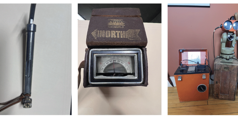
From left to right, the following tools and their purpose is described below.
MEASURING DISTANCE BY FEEL
Primary use: late 1800s – 1980s
One of the simplest but most critical tools was the Tape Tension Scale, or spring balance. Surveyors used steel tapes to measure distance, but those tapes could stretch depending on how hard they were pulled.
To keep measurements consistent, surveyors would apply a specific amount of tension—often between 10 and 20 pounds—using the scale. It was a small step, but essential for accuracy, accounting for stretch, sag, and even temperature.
Today, distance is captured instantly with electronic instruments—but it used to depend on steady hands and careful control.
READING THE EARTH’S MAGNETIC FIELD
Primary use: 1700s – early 1900s (surveying/geophysical crossover)
Another fascinating tool is the Dip Needle, which measured the vertical angle of Earth’s magnetic field—something a standard compass can’t do.
Surveyors and early geophysical explorers used it to detect magnetic anomalies, locate iron deposits, and even find buried objects. It was an early example of using science to “see” what couldn’t be seen above ground.
Modern surveyors achieve similar goals with magnetic locators and advanced detection tools—but the principle remains the same.
THE SHIFT TO ELECTRONIC PRECISION
Primary use: ~1950s – 1980s
The introduction of Electronic Distance Measurement (EDM) marked a turning point in the profession.
Instead of relying on chains or tapes, EDM instruments used light waves to calculate distances with far greater speed and accuracy. Surveyors could send a signal to a reflector and measure distance based on the return—laying the groundwork for the total stations we rely on today.
It’s hard to overstate how transformative this was. What once took hours could now be done in minutes—with better results.
FROM THEN TO NOW
Surveying has always been about precision—but the tools have evolved dramatically.
What hasn’t changed is the role surveyors play in shaping the built environment. Whether using a steel tape or satellite positioning, the goal is the same: establish reliable data that projects depend on from day one.
As we recognize National Surveyors Week, it’s worth appreciating both where the profession is today—and the tools that helped get it here.